Showing posts sorted by relevance for query wannamaker. Sort by date Show all posts
Thursday, May 01, 2008
Wannamaker Ready-to-go
The driveway and parking are now in place at the Wannamaker Preserve near St. Matthews. Audubon South Carolina can now begin environmental education programs at the site, which will most immediately affect the nearby Calhoun County schools.


The trails at the Wannamaker Preserve, which is owned by the Columbia Audubon Society, have been in place for several years. However, buses could not access the property and unloading along SC Highway 6 would not be safe. It took time to secure funding for the driveway complete with a turn-around loop and a slot for buses to execute a 3-point turn. Additionally, a concrete slab was poured under the previously-completed shelter.
We're excited about the possibilities for providing environmental education in Calhoun County as are several local school teachers. These motivated teachers will have the opportunity to use the Wannamaker Preserve as an outdoor classroom and laboratory without a guide making the hour drive from the Audubon Center at the Francis Beidler Forest.
Images by Mark Musselman
Friday, September 14, 2007
Barn Raising
Okay, the staff from the Audubon Center at Francis Beidler Forest and volunteers from the Columbia Audubon Society will not be raising a barn on October 6th at the Wannamaker Nature Preserve. Instead, they will be raising an outdoor shelter. The footprint of that outdoor facility is outlined in tape in the image. The shelter will provide students with an area to spread out their collected treasures (leaves, insects, soil) or to escape the sun or rain.
The Wannamaker Nature Preserve was donated to the Charleston Audubon Society by the late by Mr. Jack Wannamaker and has since transferred to the Columbia Audubon Society. The preserve east of St. Matthews straddles Lyons Creek and is bordered by SC Hwy 6 and Beacons Light Road. Hopefully, the 2.5 miles of trails will soon be trod upon by students from local schools eager to learn more about the plants and animals in their backyard. However, before any of that can happen, a driveway and parking area must be constructed away from Hwy 6 to allow the students to safey exit their bus. Funds have yet to be provided for the driveway parking area, and bathroom facilities.
If you would like to help with the shelter construction or with financial support for the infrastructure required to begin environmental education programs, please contact Mike Dawson at 843.462.2150.
Thursday, September 20, 2007
Pole Raising
Today, not everyone was upset that it was overcast, cool and raining. Some of the staff from the Audubon Center at the Francis Beidler Forest found the conditions quite pleasant for their work. They were at the Wannamaker Nature Preserve to set the poles for the shelter that will be used for educational programming. Digging holes for the poles and setting them in concrete would have been been taxing in the sunshine, high temperatures and high humidity.
The Amish barn-raising teams need not fear the South Carolina competition. However, it should be noted that the poles that are leaning in the image have yet to be set. As has been noted previously, the shelter is an important first step towards providing educational programming at Wannamaker. Next, the driveway and parking areas. Would anyone care to volunteer the funds?
Friday, May 29, 2009
Students at Wannamaker Nature Preserve!
Wannamaker Nature Preserve is owned by the Columbia Audubon Society chapter with educational programming provided by the Audubon Center at Francis Beidler Forest. Although the trails have existed for years, the lack of a shelter, bus access and parking, and restrooms have prevented local Calhoun County schools from using the outdoor laboratory. That all changed this week with 3rd graders visiting on Tuesday and 4th graders visiting on Wednesday!
Even though the restroom will not be installed until next month, the proximity to the schools (7-minute bus ride) and the brief time at the preserve allowed schools to work around the issue. As noted in earlier blogs (1, 2, 3), the driveway, parking and shelter issues had already been resolved.
These first visits were intended to familiarize students and teachers with the site. Chris Russell runs the elementary school science lab and was the liason between Audubon and the Calhoun County School District. The 3rd graders walked along the trails and reported what they saw to the adult
recorders. The lists included: Southern Toad, Ebony Jewelwing Damselfly, fungus, spiders (multiple species!), poison ivy, pine trees, sweetgums, deer tracks, blackberries, ants and ant piles, lizards, Blue Jays, Yellow-billed Cuckoo, flowering Spanish Moss, funnel web spiders, dragonflies, mosquitoes, ticks (yuck!), ferns, grasses, acorns, pecans, Carolina Wren nest in shelter, etc. Back in the classroom, students will create food chains and food webs based on the organisms they encountered during their walk!

The 4th graders saw much of the same life when they visited the next day.
However, they took their visit up a notch by creating an event map of their experience. Working in pairs, students sketched their path through the preserve, made notes of their observations, and sketched items of interest. Therefore, each map had similarities (picnic shelter, trail, driveway), but each map was unique based on the creators' interests (not every student added ticks or spiders). Things were going quite well for the first group as we were about to complete the full blue trail circuit. Five minutes from the shelter, the sky opened and rained for exactly five minutes. We were soaked, all the maps disintegrated, but there was nothing but laughter. The second group fared better when it came to the weather.
Images by Mark Musselman
Labels:
calhoun,
school,
wannamaker
Friday, May 21, 2010
Wannamaker Nature Preserve
Today at the Wannamaker Nature Preserve, Audubon South Carolina hosted 4th graders from Guinyard Elementary School in St. Matthews, SC. In the past, the lack of restroom facilities have limited access to the nature preserve, but the site now has a restroom, shelter, bus parking, and miles of trails.
The first activity was the mammal track activity. Students moved between the eleven stations and used the track key to determine the identity of the animal track in the clay. The rubber scat at some stations was an extra clue. The size of the scat for the feral hog and the black bear were big hits with the boys.
After the track activity, the six Ss of birding were discussed. The six Ss are size, shape (body, head, wing, leg, and tail), shade (color and markings), surroundings, style (behaviors and how they are performed), and sound. The heat of the day kept the birds to a minimum, but students did identify by sound a Blue Jay, Mourning Dove, American Crow, Northern Cardinal and Carolina Wren. A Turkey Vulture was spotted soaring overhead and a variety of food items (berries, seeds, insects, and spiders) were identified in the habitat. Several students asked if any birds eat the ubiquitous ticks!
Images by Mark Musselman
The first activity was the mammal track activity. Students moved between the eleven stations and used the track key to determine the identity of the animal track in the clay. The rubber scat at some stations was an extra clue. The size of the scat for the feral hog and the black bear were big hits with the boys.
After the track activity, the six Ss of birding were discussed. The six Ss are size, shape (body, head, wing, leg, and tail), shade (color and markings), surroundings, style (behaviors and how they are performed), and sound. The heat of the day kept the birds to a minimum, but students did identify by sound a Blue Jay, Mourning Dove, American Crow, Northern Cardinal and Carolina Wren. A Turkey Vulture was spotted soaring overhead and a variety of food items (berries, seeds, insects, and spiders) were identified in the habitat. Several students asked if any birds eat the ubiquitous ticks!
Images by Mark Musselman
Wednesday, April 15, 2009
Street Level Google Earth

Daugther #1 came home last night and confessed to getting caught off task in Language Arts. She was looking at our house using Street Level in Google Earth. We knew the large metropolitan areas were being covered by the Google Earth Street Level cameras, but we did not realize that they had gotten down to the streets of small-town Summerville. The fact that the folks in a small village in England had risen up and chased away the Google Earth Street View car should have clued us in that we were on the list for picture day.
The car and camera did not make it to the Audubon Center at Francis Beidler Forest. The closest they got was across Four Holes Swamp to the east at 2432 Old Gilliard Rd where one can look down the powerline that runs across the swamp approximately 100 meters north of the nature center. The Silver Bluff Audubon Center received much better coverage. A multitude of images can seen in both directions from the offices at the 4518 Silver Bluff Rd. image. Type in your address and see if you've been imaged!
Audubon South Carolina has its own Google Earth files. You can find the hyperlinks at the bottom of the Francis Beidler Forest education department's curriculum page. The files show the Four Holes Swamp watershed boundary, the Francis Beidler Forest boundaries, the Francis Beidler Forest boardwalk, the Francis Beidler Forest canoe trail, the Wannamaker Nature Preserve near St. Matthews, the McAlhaney Nature Preserve along the Edisto River, and the boundaries of the Silver Bluff Audubon Center near Aiken.
You can also see images from along the 1.75-mile boardwalk through the old-growth of Francis Beidler Forest by enabling the Panoramio feature under the Geographic Web heading on Google Earth.
Image from Google Earth
Monday, October 08, 2007
Raising the Roof
On Saturday, staff from the Audubon Center at Francis Beidler Forest and volunteers from Audubon chapters in the state joined to raise the roof on the outdoor shelter at the Wannamaker Nature Preserve near St. Matthews.
With the poles already in the ground and bolted together during previous visits, the mission of the day was to get as much of the roof installed. As the 11-hour timeline of images below shows, that involved cutting the poles to size, hoisting and securing the nine trusses, attaching the plywood roof, attaching the tar paper, and scheduling the shingle installation (ran out of daylight) for this Wednesday.

5:40 pm - plywood roof almost complete; tar paper on one side

6:20 pm - roof complete along with drip edge

6:45 pm - tar paper being completed on second side
7:30 pm - the final four workers heading home to Summerville
With the poles already in the ground and bolted together during previous visits, the mission of the day was to get as much of the roof installed. As the 11-hour timeline of images below shows, that involved cutting the poles to size, hoisting and securing the nine trusses, attaching the plywood roof, attaching the tar paper, and scheduling the shingle installation (ran out of daylight) for this Wednesday.
8:25 am - workers and supplies arrive; poles already in ground
9:10 am - 3 trusses (ends & middle) hung upsidedown; (l to r) Dick Watkins in orange hat, Collis Boyd on ladder, Mike Dawson near ladder, Dan Tufford [Pres. of Columbia Audubon], Steve Dennis, Nick Dawson, and Ted on blue ladder; Alice pruning around driveway and parking area.
12:45 pm - 3 trusses upright
6:20 pm - roof complete along with drip edge
6:45 pm - tar paper being completed on second side
7:30 pm - the final four workers heading home to Summerville
Tuesday, February 13, 2007
Audubon South Carolina - Google Earth

The Google Earth (kml) files for all of the Audubon South Carolina properties are now available on the Francis Beidler Forest education curriculum page. The image shows the Audubon Center at Silver Bluff Plantation along the Savannah River near Aiken, SC.
The Wannamaker Preserve near St. Matthews, SC is being transferred from the Charleston Audubon Society to the Columbia Audubon Society. Audubon South Carolina has created trails within the preserve and is developing an environmental curriculum to serve the students of Calhoun County.
McAlhany Preserve is on the Edisto River west of St. George and is owned and maintained by the Charleston Audubon Society. Note the beautiful oxbow lake within the property. Longleaf Pine trees are being planted north of Wire Road in the area that appears bare.
Friday, March 30, 2012
Bird Arrivals This Week
It has been a busy week at the Audubon Center at Francis Beidler Forest. Unfortunately, we have spent almost all of it elsewhere! The education department conducted three days of programming (birds, food webs, and mammal tracks) with St. Matthews Elementary and Sandy Run Elementary Schools at the Wannamaker Nature Preserve outside of St. Matthews. Wednesday was spent at the Charleston Air Force Base's Earth Day helping 5th graders from the tri-county area identify macroinvertebrates in samples we collected from the swamp. Therefore, we have only had time for some quick, late afternoon excursions onto the boardwalk to discover what bird species have arrived back from their wintering grounds.
Here are the bird species that are new this week:
The second male, A014, is singing around #130 and was banded from the boardwalk on April 19, 2011.
Red-eyed Vireos are singing along the edges of the swamp and in the parking area, but the Ovenbird we spotted was silent except for a slight rustle of the leaves.
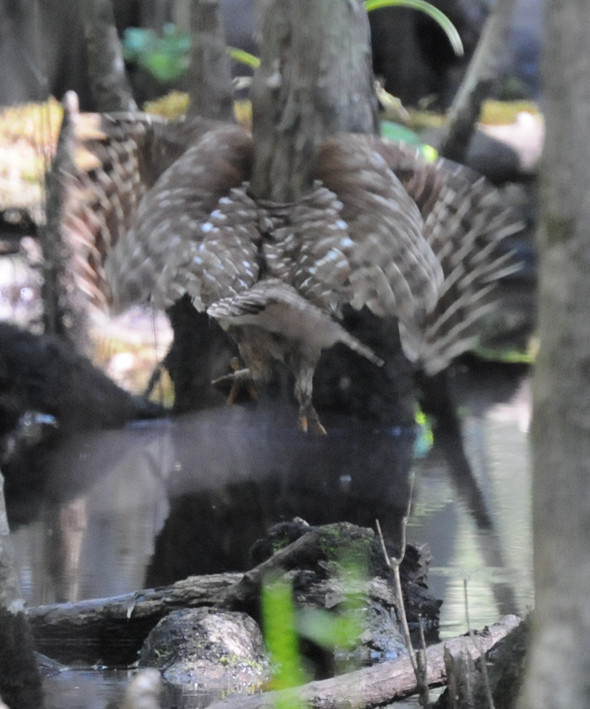
Although Barred Owls are here all year, they are especially active now during the day as they have extra mouths to feed. The pair that nests along the backside of the boardwalk between #13 and #17 are prodigious hunters and quite photogenic. We have previously reported this pair hunting Wood Duck ducklings, Yellow-bellied Sapsuckers, and crayfish.
While running an errand on the boardwalk this morning, we caught sight of a Barred Owl wrestling with something on a log in the water. Using the binoculars, we realized that the owl had a turtle, but we could not identify the dark, wet turtle carapace clutched in the talons of the owl.
After much effort, the Barred Owl was unable to extract the turtle from its shell. The owl flew to a branch over the water to watch for easier prey and eventually took a moment to stretch and preen.
After the owl departed, we went into the creek to find what might be left of the turtle in order to identify the species. We found the Eastern Mud Turtle shown below. The Eastern Mud Turtle has a hinged forward section on its plastron (bottom portion of shell) that can be closed like a box turtle's in order to protect the head and much of the front legs. The turtle can pull in its rear legs and tail so that they are flush with the plastron. Unlike the musk turtle, the mud turtle's plastron covers and protects most of its underside. The only sign of injury on the erstwhile breakfast item was a small bone protruding from the underside of the front right leg, which didn't seem to affect the turtle's ability to use the limb.
The owl got an A for effort, but did not have time to contemplate the missed meal. Soon after turning its attention from the resilient reptile, an owlet began its begging cry and the adult focused on catching something easier to open!
Here are the bird species that are new this week:
- Prothonotary Warbler
- Swallow-tailed Kite
- Chimney Swift
- Red-eyed Vireo
- Ovenbird
| Prothonotary Warbler A250 with caterpillar - Mark Musselman |
| Prothonotary Warbler A014 - Mark Musselman |
Red-eyed Vireos are singing along the edges of the swamp and in the parking area, but the Ovenbird we spotted was silent except for a slight rustle of the leaves.
| Ovenbird - Mark Musselman |
While running an errand on the boardwalk this morning, we caught sight of a Barred Owl wrestling with something on a log in the water. Using the binoculars, we realized that the owl had a turtle, but we could not identify the dark, wet turtle carapace clutched in the talons of the owl.
| Barred Owl with turtle - Mark Musselman |
| Barred Owl with turtle - Mark Musselman |
| Barred Owl with turtle - Mark Musselman |
| Barred Owl with turtle (left talons) - Mark Musselman |
| Barred Owl with turtle - Mark Musselman |
| Barred Owl - Mark Musselman |
| Barred Owl - Mark Musselman |
| Eastern Mud Turtle - Mark Musselman |
Thursday, February 01, 2007
Google Earth Files

Google Earth files (.kml) have been created to show the boundaries of the Francis Beidler Forest in Four Holes Swamp; the boardwalk through the virgin, old-growth forest; the canoe trail through the virgin, old-growth forest; the hiking trails and scout camping area; and the boundaries and trails at the Wannamaker Preserve near St. Matthews. The image shows portions of the FBF boundary in red, the canoe trail in blue, and the 1.75-mile boardwalk in yellow. The nature center is at the west end of the boardwalk. The alligator can be seen in the hole (Goodson Lake) at the east end of the boardwalk.
Google Earth provides satellite imagery of the planet in conjunction with data layers that may be selected by the user. The data layers include roads, population centers, points-of-interest, geologic activity, and in our case, boundary lines and trails. These Audubon South Carolina files will be posted for download on the Francis Beidler Forest education curriculum page. Lessons and activities will be developed for these files and this technology. As a pre-trip activity, we believe exploring the images of Four Holes Swamp, the boardwalk, and the surrounding area will help students put the swamp ecosystem into context and enrich their on-site experience.
Wednesday, August 29, 2007
Let's Hear It For The Seeps!

Dr. Dan Tufford, Department of Biological Sciences at the University of South Carolina, has an interest in watershed ecology and water resources management. Along with Steve Bennett, herpetologist for SC Department of Natural Resources (SC DNR), they have been studying the hydrology and salamander communities for seeps at the Francis Beidler Forest and the Wannamaker Nature Preserve near St. Matthews. The boards in the image are placed and then revisited once salamanders and other fauna have sought shelter beneath them.
Seeps are small, poorly-understood wetlands that occur at the base of slopes, generally at the outer edge of a floodplain or stream corridor. They are supplied by groundwater flow from adjacent sloping land.
"There is a need to better understand the characteristics, functions, and landscape matrix within which seepage wetlands occur so that we can know their ecological roles, rather than infer them as is currently the situation. Filling the knowledge gap about these wetlands is particularly urgent at this time. The Coastal Plain is under increasingly intense development pressure. Although these wetlands may be ubiquitous in a particular landscape, individually they are frequently quite small and are perceived by many to be unimportant, and thus expendable. A lack of knowledge of the ecological and environmental roles of these wetlands makes it difficult to argue persuasively for their protection. "--Tufford, Nelson, Bennett (SC DNR), Harrison (CofC)
Today, Dr. Bud Badr, Chief of Hydrology; Dr. Bill Clendenin, State Geologist, and Dr. Ralph Willoughby, geologist, all from SC DNR, were present to visit the Beidler Forest seep sites and to hear a research proposal from Tufford and Bennett. The proposal calls for geologists to determine the geologic profile for the land around the seep and for hydrologists to create a model to determine the area around the seep necessary to maintain water flow within the seep. As noted in the paragraph above, a better understanding of "characteristics, functions, and landscape matrix within which seepage wetlands" is critical to understanding how to protect these specific wetlands.
Subscribe to:
Posts (Atom)